
Zoo Baba Fm
Type Locality and Naming
Seen by G. Rohlfs in 1868, found in 1941 by Chief Warrant Officer Gobin, studied by R. Furon (1942) and Ph. Renault in 1954. Furon, 1942, emend. Faure, 1954 & 1966.
References: Furon, 1942; Faure et al., 1956; Greigert et al., 1958; Faure, 1954, 1959, 1966; Furon, 1964; Fabre et al., 1983; Meister et al., 1994; Mathey et al., 1995; Konaté et al., 2019.
Synonym: Synonymy: "Calcaires de Zoo Baba"; "Série de Zoo Baba". Often referred to as the "Cenomanian-Turonian" interval when dealing with units in the Téfidet Sub-Basin, or as Zoo Baba-Arentigué.
Equivalent(s): Iguéllala Mountains Fm; Béréré Fm; Arentigué Fm
Lithology and Thickness
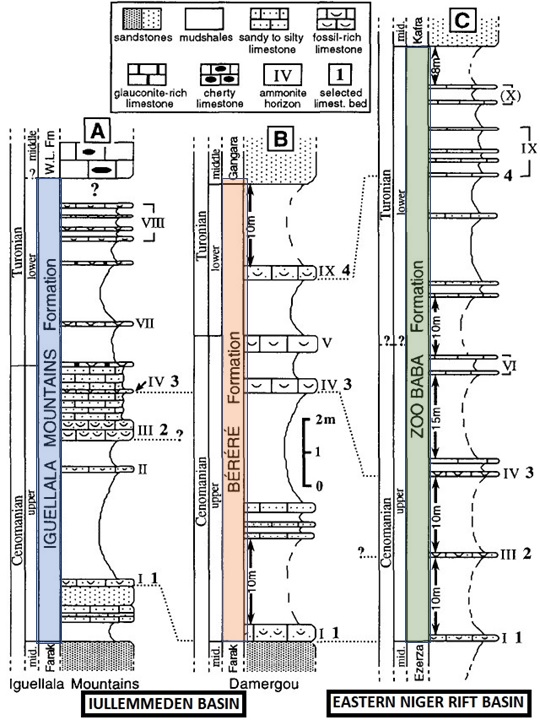
Grey, pink to black fossils-rich limestones including ammonites (Figure), gastropod, and lamellibranch debris (Exogyra olisiponensis). This level, also known as the Zoo Baba-Arentigué Fm, also includes green gypsum-bearing shales with oysters and sea-urchins (Cidaris taouzensis). Thickness: 250 m in the Termit-East and Bilma Sub-Basin. In the Téfidet Sub-Basin, the Zoo Baba Fm – Arentigué Fm, defined as the “Série Cenomanienne-Turonienne” by Faure (1959), is 60 m thick
[Figure. Lithology of the Zoo Baba Fm of the Eastern Niger Rift basin and its lithological correlation with the Iguéllala Mountains Fm (central Iullemmeden Basin) and the Béréré Fm of the Damergou area (eastern Iullemmeden Basin) (Source: Mathey et al., 1995).]
Relationships and Distribution
Lower contact
Underlain by the Ezerza Fm
Regional extent
East Niger Rift Basin - Termit-East, Bilma & Téfidet sub-basins
GeoJSON
Fossils
Ammonites: Neolobites, Metengoceras, Nigericeras, Hoplitoïdes (Fabre et al., 1983), as well as fishes (Ceratodus africanus, C. humei, Coelodus plethodon, Enchodus lamberti, Onchosaurus pharao) (Greigert et al., 1958).
Age
Depositional setting
Marine
Additional Information